80 miles to Beaufort MM202

This was another pretty leg of the trip, we made it to Beaufort in 2 days.  Our stopping point was Swansboro, which was 53 miles away.  We departed Wrightsville Beach around noon time Thursday.  Full of fuel and with Louis on lunch duty we were off having a great day.  Heading north we passed Figure Eight Island, Topsail Beach and Surf City .  Surf City has a 12′ swing bridge so this is an area most boats have to request an open.  You pass through parts of Camp Lejeune which is very cool, you can hear them blowing things up and can see military personnel on the banks of the ICW.  There is one section they have old combat tanks they have used for target practice from across the ICW just sitting there all shot to pieces.  Onslow is a town you pass just after Camp Lejeune and they also have a 12′ swing bridge that will gladly open for you.

IMG_2223

On from Swansboro we took the ICW north passing Bogue Sound, here we could see Indian Beach, Emerald Isle Beach and Atlantic Beach.  Morehead City, Beaufort, Ft. Macon State Park and Shackleford Banks are all neighboring areas here. We arrived at Beaufort around 10:45AM.  Beaufort was known as “Fish Town” in the early 1700’s when Blackbeard frequented the coast, “Beaufort Town” was established as a seaport with the right to collect customs in 1722. During the American Revolution, it was the third largest port in the state.  We got a slip at Beaufort Town Docks and we are right on the downtown boardwalk!  The town docks have a fleet of Station Wagons so if you need a vehicle while here they will loan any of them out

IMG_2240


IMG_1516


74 miles to Wrightsville Beach MM283

Grand Dunes Marina is a great stopping point on the ICW, we pulled out of here around 7am on Sunday.  What a great morning, 66 degrees outside and a nice NW wind.  This run is great because you can see the Atlantic from the Intracoastal in spots, and the water clarity gets better.  There are at least a dozen spots to stop and eat or spend the night along this route.  The Little River takes you through Myrtle Beach, then you hit the North Carolina border.  From here the ICW takes you just west of Sunset Beach and Ocean Isle Beach, continuing past Monks Island and Holden Beach.  Lots of the ICW in this area is just referred to as the Intracoastal where in other places they name them after rivers.  You pass Oak Island then enter Cape Fear River, Cape Fear has some of the longest shoals in the country.  They extend over 20 miles offshore, referred to as Frying Pan Shoals.  Going north on Cape Fear River the channel was huge and over 40′ deep.  We took Carolina Beach Inlet to the New River, then took a heading of 000N which took us straight to Wrightsville Beach using Motts Channel.  We anchored in a spot only the locals can get you in at, you can hear the waves on the beach at night from this spot.

sunken shrimp boats, one you can see one on the bank of the ICW

Carolina Beach is the one with all the cars parked on it, the tug pictured was at least 50 years old.  and they have a crane truck in a barge that they are removong pilings with which is a sight.  The big blue research boat is “OCEARCH” which is a Great White Shark Tagging and Research Vessel.  It is featured on Discovery Channel.

My great friends the Blacks welcomed us as we came up Motts channel in their boat, and lead us to the special anchorage.  I met Chris and Candice over 4 years ago in Pensacola, and we have stayed in touch ever since.  They showed us a great time after we arrived in Wrightsville around 5PM.  We took Chris’s boat all over, they showed me the lay of the land and all the great spots to go and see.  And we had some awesome Mexican food.  We will be spending lots of time with them while we are in the area.  We took Chris’s Boat out Masonboro inlet sunday night, they have a super long jetty and on the Leeward side it stays calm.  The full moon was beautiful and the waves from the atlantic breaking against the windward side of the rocks was pure bliss.  We could feel the spray from the waves.

Pura at anchor

IMG_1342

Masonboro Inlet and a picture from the “OCEARCH” shark pin.  The Masonboro Inlet has an open area on the northern jetty called a Wear.  This allows for the longshore current to keep sand from building up in the inlet.

IMG_2186IMG_2195

Docked at bridge tinder marina. Two Carolina boats to my stern


53 miles to Myrtle Beach MM357

We left our anchorage in Minim Creek around 8:30am, the wind was blowing 15-25 but the forecast was good.  We could easily make it 53 miles to Myrtle Beach today.  Minim Creek anchorage is great only a few hundred yards off the ICW in a 12-20′ deep water, it’s very scenic.  Leaving here heading north you go through the Esther Ville Minim Creek Canal then into Winyah Bay which takes you past the Georgetown Marinas.  Then on to the  Waccamaw River which takes you all the way to Myrtle Beach.  Grande Dunes Marina is a very nice establishment with a good transient set up, the hotel blocks all wind from the north and east so it is a good ICW pullover directly off the trench.  There is a Ruth Chris steak house right next to the dock.  Tyler and Rebecca took a bus back to Charleston after helping clean up the boat, they were awesome company and help.

IMG_2139

The foliage has really started to change as I leave the Low Country and get closer to the Outer Banks

IMG_2131

Its like one big bayou cruise

IMG_2137

check out the kids chilling under this bascule bridge

Docked at Grande Dunes Marina

60 miles to Minim Creek MM 410

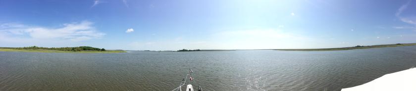
Todays cruise was beautiful, I was so happy to be leaving Charleston City Marina.  We took the south channel down Ashley river to the ICW and headed north.  We passed Isle of Palms and Pine Island, this part of the ICW is man-made and more straight than the last couple hundred miles I have done.  60 miles in this area really looks far on a map because the ICW is so straight and we covered a lot of land.  As soon as we hit statute mile 420 with 5 miles left we were in Four Mile Creek Canal, this cut runs between Six Mile Creek and Pleasant Creek.  At this point I could see a huge weather front making its way to us, the radar was scanning and we could see it as it came upon us.  The front was moving SE at 40 mph with 60mph gusts rain and some hail.  Once the storm hit the warm water it exploded with water spouts that only lasted a few seconds.

The beginning of the ride was beautiful, you can see Ft. Sumter in the distance.

Part way through the front

image1

I was watching this storm come across the miles of marsh, it was moving very fast pushing a lot of water and debris our way.  It was almost like a scene out of the movie Twister.  We hurried and zipped up my enclosure.  I kept the boat in gear just slowly going north to south, this canal was short only 2 miles long by 200′ across.  When the strong gusts hit us the boat healed over pretty good but nothing to worry about.  I kept the engines in gear and with her keel Pura Vida pushed straight through the canal.  We had at least 60mph gusts, I’ve never been in such a confined space in this heavy of weather.  Luckily my boat is strong and the canal kept us safe during the blow that lasted about 30 min.  About 8 jet skis and a 34′ Sailboat were in this cut with us during this storm, I’m not sure what the jet skiers were doing out but they were getting nailed by rain and wind.  They took off before the storm ended, I felt bad for them being so exposed to the elements.  One even tried to ride along side my boat and use Pura Vida as his shield following on the lee ward side of us.  This wasn’t a safe spot for the jet skier to stay.  The sailboat was crossing Six Mile Creek when the storm started really getting bad, he had probably 3′ waves hitting his starboard beam.  And such a hard east wind his mast was at quite an angle.

This was a good experience, and I am glad we chose to run inside this day.  At our anchorage we met two nice fellows one of whom was Captain Kai Hansen, a well-known sea farer.   His wife paints all the murals inside the Bass Pro Shops all over the country.  He was taking his newly purchased boat back up to Liverpool PA.  They had been traveling in the Atlantic from Key West for the last 4 days.  They came inside the ICW today and got caught in the wind and weather I did and ended up nosing the boat into the marsh.  You are so exposed driving a sailboat.  I’m so thankful to have my friends with me, they were able to secure things during the blow and help keep me calm.  We only lost 1 flag and some life jackets out of the dingy.  My canvas enclosure sustained slight damage, but nothing that can’t be fixed.  Im so blessed that we were taken care of in this situation.  I thank God and Mother Nature, for keeping Pura Vida safe in these ever-changing waters, that we love to roam every day,  What could be better!

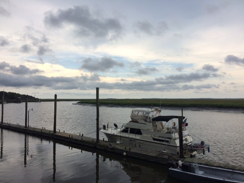
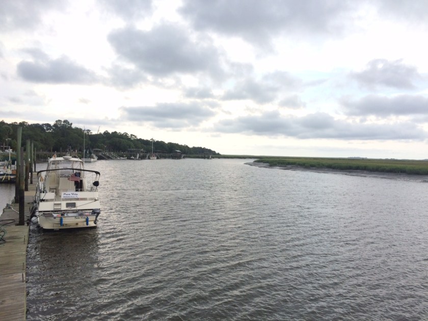
We anchored in a great spot called Minim Creek at MM 410 about 7 miles south of Georgetown.  This was a great spot to spent the night.
IMG_1145

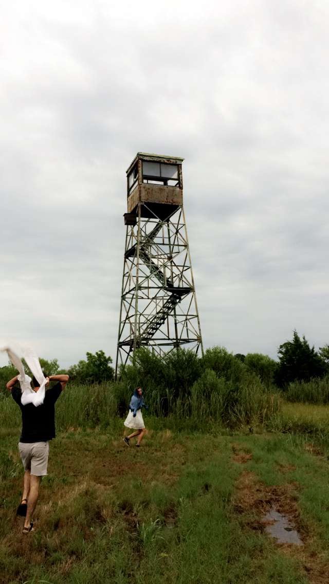
We explored a old fire tower but got so badly attacked by mosquitoes and horse flys we had to leave.  Tyler and his girlfriend Rebecca were running after being bit in this picture

IMG_2108

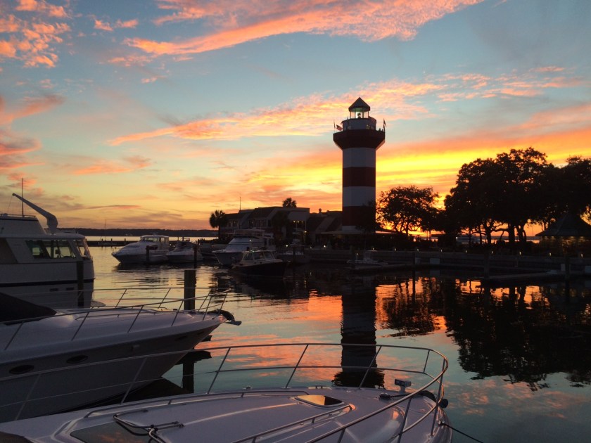
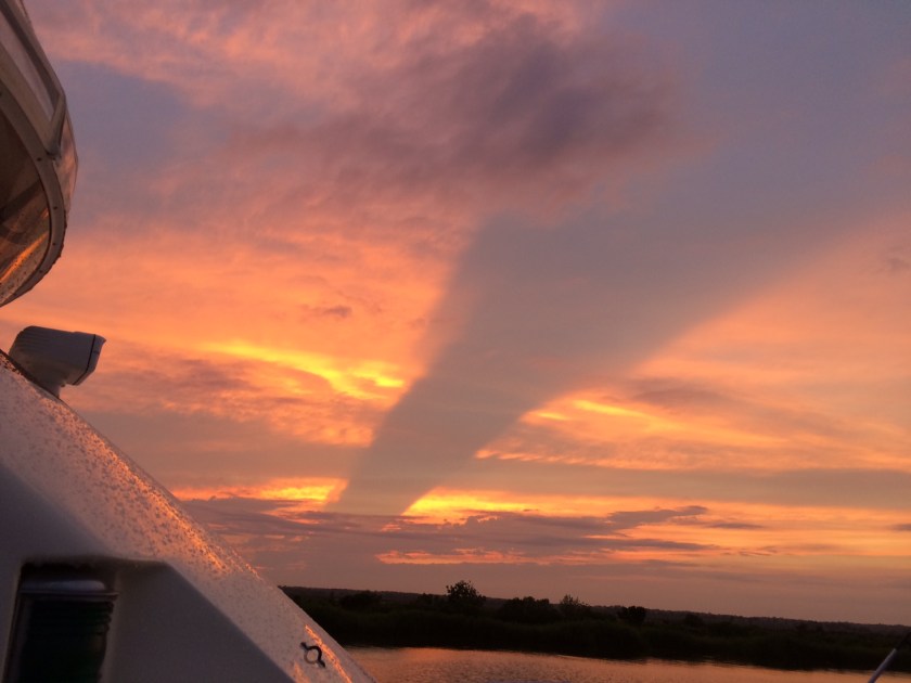
red sky at night sailors delight

IMG_2116

some good home cooking

IMG_2121

IMG_2119

52 miles to Charleston

The anchorage at Morgan Island was great and the mud held the anchor well, we got to see a bunch of monkeys dolphins and birds while staying here.  leaving Morgan Island we back tracked up to the Coosaw River.  From here we went through the narrow and shallow Ashepoo Coosaw Cutoff, we hit this at dead low tide and my depth readings were 5.5′ or greater so of course I did this stretch at idle incase we came in contact with any sand or mud with only 1.5′ to spare under the keel.  Entering Rock Creek we rode this for a short distance, and then turning onto another narrow cut off that is unnamed but is at Statute Mile 515.  This cut off was deeper and took us onto the Ashepoo River.  Cutoffs are man-made channels that cut some time off the natural river, rivers wind like a snake and the cutoffs make it more direct.  These require dredging and that’s why you find shallow depths in these areas sometimes.  From here we took Fenwick Cut to the South Edisto River, the ICW stays narrow for about 8 miles here then turns into Stono River.  Stono River takes you to Elliott Cut, this is narrow and lined with houses and boat docks.  We transitioned this Cut on Saturday and the recreational boaters were out in full force,  we went slow and the crowds of boats parted as Pura Vida passed through.  This cut empties out into Ashley River and your directly across from Charleston City Marina.

monkey in the trees, sorry its blurry

IMG_2032

anchored at Bass Creek, You can see a water spout trying to form over the Atlantic in the distance of this one photo

IMG_1964IMG_1963IMG_1982

IMG_1983

A grey barge that was just painted, old casino river ferry, and other pictures of the South Carolina Low Country

IMG_1984IMG_1986

Tylers Mom Margaret made us a great home cooked meal the night we arrived, it was great to see her and have some wonderful food in the comfort of her home!

IMG_1998

IMG_2004

 We swam on the Congaree river in Columbia SC Sunday, and here is Tylers Landcruiser and Motorcycle

The Charleston City Marina is probably the worst marina i’ve been to this far, docks are in bad shape with exposed rusty metal sticking out all over and cleats missing.  The people who work here are not as friendly as you would hope, and I have not figured out why.  This Marina seems to have no Dock Master or Manager.  Boaters in the channel fail to abide by the no wake zone signs so the marina is very rough all the time during the day. I hate to put something negative about a marina but this is the truth and they have not made me think differently, I would not want to mislead any of my readers.  Other marinas really appreciate your business and treat you like family.  In Charleston I would look elsewhere. 

60 miles to Bass Creek

Departed Hilton Head Island around 9am headed north on Calibogue Sound then on to Skull Creek, and entering Port Royal Sound where the Chechessee and Broad River combine.  Took a swim in Port Royal Sound to cool down, then north on Beaufort River through downtown Beaufort.  Continuing onto Coosaw River, we explored Morgan Island from the water looking for the monkeys that live here.  We took a anchorage in Bass Creek part of Morgan Island so maybe we will see some monkeys later today.  Tomorrow we will make it to Charleston.

IMG_1954

Morgan Island is one of the Sea Islands, located in Beaufort County, just north of Beaufort. It is also known as Monkey Island due to its colony of free ranging rhesus monkeys, established in 1979

IMG_1962

IMG_1961IMG_1960

21 miles to Hilton Head Island

This short day’s run was awesome, spent the morning and first part of the afternoon still exploring Savannah.  Since this was only a 21 mile run, we left River Street around 2:30pm. The current was ripping, seemed to be at least 4mph.  Heading down Savannah River was fast and easy, 1,000 Rpms had me going 12mph with the flow of the river.  Leaving Savannah River we took Fields Cut to Wright River. From here we followed a USCG tug and barge all the way through to Ramshorn Creek, then Cooper River which empties into Calibogue Sound directly across from Hilton Head Island.

IMG_1908

Charles Frasier had a vision when he developed Hilton Head Island, that was for families and visitors to come and be able to look up and see the stars.  That’s why there are no neon lights on the island.  The island is now 98% developed and yet one can always look up and see the stars; they also have a huge number of sea turtles who still come to the island to nest.   Hilton Head Harbour Town Yacht Basin is a great spot with free shuttles to the beach and resort amenities access as a marina guest.  Hilton Head Island is part of the Lowcountry region, the Harbour Town Lighthouse and Museum marks the southwest tip.  We had some great food here and got to swim in the Atlantic.   Mike Drake, a great friend of the family, who lives here, came to see us and Pura Vida.  It was awesome to spend some time with him, and he shared much nautical wisdom and local knowledge of SC.  It was also cool to see his 02 7.3L F350, one of the last good diesels around, almost at 300k. Hopefully this can be my next truck when he wants to sell it.  We had a great meal at Quarterdeck right on the marina and shared some great wine and views.  My really good friend, Tyler Crochet, had his friend Scott drive him down from Charleston today so he can ride back to Charleston with us.  Tyler has been living in SC for 5 years now, it sure was great to see him, and we have a fun time ahead of us.  Courtney has been great to have aboard, she has been with me since Amelia Island and has been a great help.  Her grand dad has done the loop twice and has taught her good boating knowledge, its been a treat.

IMG_1920

FullSizeRender

IMG_1917


44 miles to Savannah

We departed Kilkenny Marina around 8AM Monday, tropical storm Colin had us in light rain and overcast skies the whole day.  Getting back to the ICW from Kilkenny we took Bear River then went through a narrow cut called Florida Passage that took us onto the Ogeechee River.  To get from here to the Vernon River you have to go through Hell Gate a shallow passage that takes you to Skidaway River and finally the Savannah River.  The Hyatt has a good, long dock for boaters that want to stay for a while and enjoy this cool town.  There are 3 other marinas on the main drag, and you have to call in advance to get reservations.  We did this leg of the trip during high tide because Hell Gate is literally Hells Gate during low tide.

Right before sunset at Kilkenny Marina

  IMG_1805

Savannah is so rich in history.  It was established in 1733 and was the first colonial and state capital of Georgia.  You would probably need a week here to see everything.  Trolley tours are a good way to see the city. they can let you off anywhere and the drivers are good at talking about the city.  Dave from the UK was my favorite guide.  There is a lot of commercial traffic on the Savannah river at night, it rocks the boat, so a good fender system is a must.  Savannah is the second largest port in the US for export.

Rainy Commute

River Queen

IMG_1827

Pura Vida at dock

Model ships at the Maritime Museum and real ships, you can see two passing each other and how tight it is.

Streets were originally paved with ballast rocks from the ships coming into port.  They have preserved this on river street.

Last, but definitely not least, I got to see my long time friend Kathleen Westbrook, her boyfriend Caleb, and precious Bailey.  We all had a great meal together.

IMG_1876


60 miles to Richmond Hill

Todays cruise went great, Leaving Morningstar Marina at 8am we arrived at Kilkenny Marina around 1:40PM.  The tide was with us for half the day today then against us for the other, I kicked the CAT motors up to 2150 RPMs to try to do as much of the Georgia ICW as possible during high tide.  We were making 15knots with no current then down to about 12-13kts when it started flowing against us.  My engines are workhorses, you can’t beat a mechanical Caterpillar, not the fastest but damn their reliable.  Scenery today was beautiful marsh lands with some that had good hard ground where remote homes were built and trees seem to flourish on these banks where soil is good.  We cruised the Troupe Creek East then Mackay River then little Mud River (most of these narrow caution spots have range markers so you can use these to line up and stay centered in the channel) then hit the Sapelo River then made it to St. Catherine’s Sound where we got on Bear River then Kilkenny Creek.  Today was like a maze of rivers I had a fun time.

IMG_1776

IMG_1780IMG_1778IMG_1785

Kilkenny Marina is located in Richmond Hill Georgia, I love Henry Ford and when I heard he had a historical connection to this area I had to find out more.  Fords home was built on the sight of Richmond Plantations.  Fords holdings eventually totaled 85,000 acres of agricultural and timber lands, which is now owned by the state of Georgia or ITT Rainier, a timber company.  Henry also built a number of public buildings here like the Kindergarten which is now the Richmond Hill Historical Society, and a chapel that now houses St. Anne’s Catholic Church.  Both are located on Georgia S.R. 144, also known as Ford Avenue.  The Ford Plantation has been turned into a luxury resort that is supposed to be very nice!  When it was suggested that the town be renamed “Ford”, Mr. Ford declined and instead Ways Station was renamed “Richmond Hill” after the sight of Fords home on the banks of the Ogeechee River.

Pura Vida docked at Kilkenny Marina

IMG_1803IMG_1795IMG_1801

they sell shrimp here and this Blue Heron eats good

IMG_1802

check out their unique way of launching boats here at Kilkenny. due to the 8′ tides

23 miles to St. Simons

My crew has made great meals for me and taken very good care of the boat so I am very grateful to them.  Leaving our anchorage we headed back to the ICW and took it north through St. Andrews Sound  which takes you into the Atlantic slightly and then back to the ICW there are shoals here and thats why you have to go so far out.  We then passed Jekyll Island, this ICW section goes through Jekyll Creek.  We hit this area at low tide actually 7′ low, the ICW depth is 12 in this area so we only had 5′ under the boat and the trench was super narrow.  We idled through this area, it was only like a 2 mile stretch of skinny water then back to 12-23 ft.  Well Cumberland Island is in GA and this means i’ve done the whole Florida coast, feeling very happy about this.  Georgia has these huge tidal swings though and areas where it gets very shoaly from all the current moving so this will be a good area to refine my ICW skills even further.

This was a very cool place to stop, Morningstar Marina is a great establishment dock master Mitch takes the best care of his boaters and the marina.  St. Simons is located on the southeast Georgia coast, midway between Savannah and Jacksonville, St. Simons Island is both a seaside resort and residential community.  It is the largest of Georgia’s renowned Golden Isles (along with Sea Island, Jekyll Island, and privately owned Little Simons Island). Visitors are drawn to the Island for its warm climate, beaches, shops, restaurants, historical sites, and its natural environment.  Bubba Gracias is a awesome spot to get Mexican American food and relax in a nice very friendly atmosphere.  Try the bbq burrito or the cali club tacos, they both hit the spot for me.  This is a great island for bike riding and walking, there is a natural canopy provided by the live oaks that are very large.  We met some very friendly people here that we look forward to seeing again.

IMG_1761IMG_1726